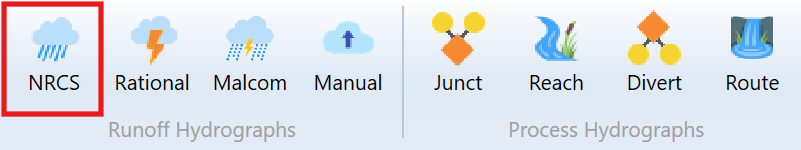
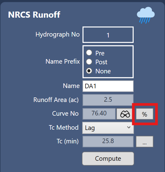
As described in the General Procedure, runoff hydrographs are added to your model by clicking one of the Runoff Hydrograph buttons on the Ribbon Toolbar at the Main Window. In this case, click the [NRCS] button. After the icon has been added, simply click on its icon or row, depending on which tab you are working from, to populate its input window. Then fill-in-the-blanks for its data and click [Compute].
Remember that the program will use the active Return Periods, Design Storm and Precipitation values as set in the Rainfall Wizard. There’s no need to enter any rainfall data here.
Required Input Data
The following is a description of each of the required input items.
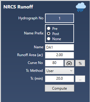
Name Prefix
You can include a prefix (“Pre”, “Post” or nothing to your hydrograph Name field with a single mouse click. This saves precious keystrokes when doing a pre- and post-development study and you want to identify those hydrographs that are “Pre” or “Post” development. The chosen prefix will be added to the front of the Name label on the Basin Model and throughout the software, for example, Tables, Charts, Reports, etc.
Name
Enter any descriptive name for this hydrograph. It will appear on the printed reports as well as the Basin Model.
Runoff Area
Enter the sub-basin area in acres (Hectares). No size limit.
Curve Number, CN
Enter the SCS Curve Number for this area. A table of CNs is available by clicking the Lookup button. The CN varies according to the Hydrological Soil Groups (A, B, C & D). The SCS hydrological soil groups are described as:
Group A soils have low runoff potential and high infiltration rates even when
thoroughly wetted. They consist of deep, well-drained sands or gravels and have a high rate of water transmission.
Group B soils have moderate infiltration rates when thoroughly wetted and consist
mainly of moderately well drained soils with moderately fine to moderately coarse textures. These soils have a moderate rate of water transmission.
Group C soils have low infiltration rates when thoroughly wetted and consist primarily of soils with a layer that impedes downward movement of water and soils with moderately texture. These soils have a low rate of water transmission.
Group D soils have high runoff potential. They have very low infiltration rates when
thoroughly wetted and consist of clay soils with a high swelling potential, soils
with a permanent high water table, soils with a clay layer at or near the surface, and shallow soils over nearly impervious material. These soils have a very low
rate of water transmission.
Composite Curve Number (CN)
Hydrology Studio has an added feature which allows you to compute a composite or weighted CN, i.e., where a single drainage area contains multiple distinct CNs. For a composite CN, press the percent [%] button. Up to six sub-basin areas and corresponding CNs can be entered for a composite CN.
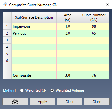
After entering the individual Areas and CNs, click the [Apply] button and then [Close]. The Composite CN will automatically populate the CN input.
Please note that in order to make subsequent edits to your drainage area(s) and CNs, you must click the [%] button again to return to the Composite Curve Number dialog box.
Calculation Method
You’ll have two options for computing the final runoff hydrograph when using composite CNs.
- Weighted CN – This method will simply use a single CN value which is a weighted composite based on area. This method will produce acceptable results when the rainfall amounts are greater than 4 inches (100 mm) and the CNs are fairly close. Unlike the example shown above.
- Weighted Volume – This method (also known as Runoff Weighted) is based on runoff volume, is recommended and will always produce the correct result. Instead of computing a single hydrograph using a single composite CN, it generates hydrographs for each specified drainage Area and associated CN. It then adds these together, same as employing a junction, to generate the final hydrograph.
Due to the nonlinear character of NRCS hydrograph equations, inaccurate runoff estimates can result when mixing pervious and impervious surfaces within a drainage area using an area-weighted average Curve Number. This combination can imply a significant initial loss that may not actually take place and will be particularly acute for small rainfalls where the large (but incorrect) initial loss can be 50 percent or more of the total rainfall, thus underestimating the runoff.
For this reason, we highly recommend employing the Weighted Volume method as it is always correct, regardless of the CNs and rainfall amounts.
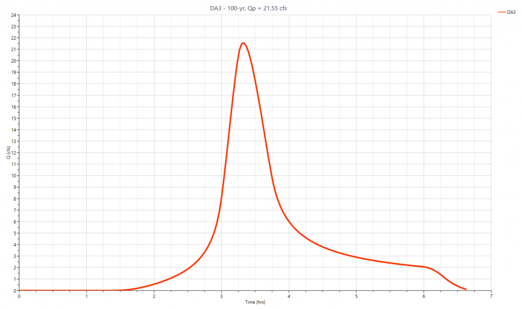
Here are two hydrographs generated using both methods. Notice the dramatic difference between the two when the rainfall is below 4 inches (100 mm).
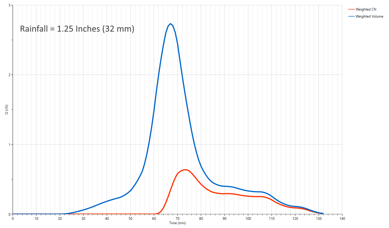 Weighted Volume produces much higher volume and peak flow with small rainfall.
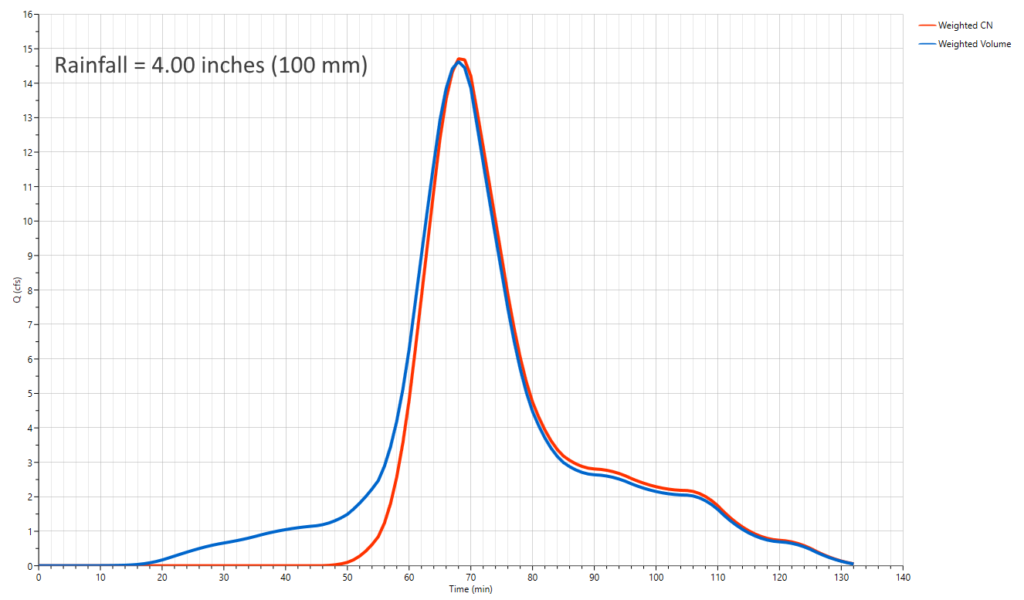
With higher rainfall both methods produce hydrographs that are nearly identical.
Time of Concentration, Tc
Tc is the time it takes for runoff to travel from the most remote upstream point in the drainage area to the downstream point in question. Select one of the four Tc options from the drop-down list box.
User – Check this option to override the computed Tc and enter Tc manually.
Lag – The TR-20 default method. Use this when the area is of a homogenous nature. Think agricultural land.
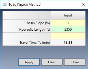
Kirpich – This method is normally used for natural basins with well defined routes for overland flow along bare earth or mowed grass roadside channels. It is similar to the Lag method but will typically give shorter times compared to the Lag method. Use this method when the subarea is dominated by channel flow.
TR55 – Compute Tc by using the built-in TR55 worksheet. See Tc by TR55.
If you chose Lag, Kirpich or TR55, click the ellipsis […] button to open the corresponding input screen. There, Tc will be computed and automatically inserted into the Tc input box.
The Shape Factor
The Shape Factor (a.k.a Peaking Factor) is a component of the NRCS method which affects the temporal pattern or shape of the Unit Hydrograph. This factor is typically 484 (0.208 metric). Check local ordinances. This value can be changed or set in the Project Settings.
The default value is set to 484 and creates a unit hydrograph that has 3/8 of its volume under its rising limb. This factor is higher in mountainous watersheds, for example, 600 (0.258), while in flat, sandy areas, will be lower, around 300 (0.129). The Delmarva peninsula in Delaware uses 284 (0.122) as does Maryland and Virginia.
Michigan DOT uses a shape factor of 368 so that 28.5% of its volume is under the rising limb. This method is referred to as the MDEQ-SCS Method and can be replicated with Hydrology Studio by simply changing the Shape Factor to 368.
Learn more about Unit Hydrograph Shape Factors here.