The Project Settings dialog allows you to specify a Project Title, Time Interval and a variety of other settings. To open, click the [Settings] button on the Ribbon Toolbar.

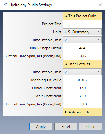
Settings are divided into three categories:
- This Project Only – Settings affect the current project only.
- User Defaults – Default values that are automatically used when you start a new project.
- Autosave Files – Options to have rainfall files saved automatically when edited. When turned off, the default, you will be prompted to save these files when edited.
Title
Enter a title for this project. This optional item will be shown on the Main Window as well as printed reports.
Units
Select US Customary or Metric. (Use this before starting a new project. Hydrology Studio cannot convert your existing project’s units.)
Time Interval
The Time Interval, or Time Steps, refers to the duration between calculations for your hydrographs. For instance, if the interval is set to 2, the software will compute the hydrograph ordinates every 2 minutes. Hydrology Studio can accommodate up to 2,880 ordinates for each hydrograph. Therefore, with a 2-minute interval, a hydrograph can cover a total duration of 2,880 x 2 minutes, equating to 96 hours or 4 days.
This duration is sufficient for most urban drainage analyses, which is why a 2-minute interval is the default setting. Opting for a longer time interval will yield fewer data points and require less computational power, particularly in terms of processing time. As you will observe, Hydrology Studio operates efficiently, and even a 1-minute interval has a negligible impact on calculation duration.
The Time Interval can be set as a default for all new projects as well as for the current project. If you’re not sure which to use, we recommend 1 minute.
NRCS Method Considerations
While a detailed explanation of the NRCS unit hydrograph theory is not necessary, it is important to emphasize that the Time Interval must not surpass 50% of the Time to Peak of the Unit Hydrograph. Exceeding this limit may result in inaccuracies in the construction of the Unit Hydrograph, which will subsequently affect the final runoff hydrograph. Hydrology Studio will provide a warning in such cases, advising you to select a shorter time interval.
Did you know, TR-20, the now-antiquated standard, used a 30-minute time interval and employed algorithms to re-construct the hydrograph near the peak to improve accuracy?
Rational and Malcom Method Considerations
It is highly recommended that you use a 1-minute Time Interval when using the Rational or the Malcom method. This prevents missing the peak Q if it would fall on an odd time increment.
NRCS Shape Factor
The Shape Factor (a.k.a Peaking Factor) is a component of the NRCS method which affects the temporal pattern or shape of the Unit Hydrograph. This factor is typically 484 (0.208 metric). Some local ordinances require different values. You can change it here.
The default value is set to 484 and creates a unit hydrograph that has 3/8 of its area under its rising limb. This factor is higher in mountainous watersheds, for example, 600 (0.258), while in flat, sandy areas, will be lower, around 300 (0.129). The Delmarva peninsula in Delaware uses 284 (0.122) as does Maryland and Virginia so that 22% of its volume is under the rising limb. Michigan DOT uses a shape factor of 368 so that 28.5% of its volume is under the rising limb. This method is referred to as the MDEQ-SCS Method.
If your local drainage requirements involve unique Unit Hydrographs or Peaking factors, please read, NRCS Unit Hydrograph Peak Factors.
Critical Time Span
Enter the beginning and ending times separated by a comma. The default is 0,0 and should remain as such unless you will be utilizing this feature.
Typical spans are between 11 and 18 hours, i.e. 11,18. Use this functionality for employing and satisfying Volumetric Detention Criteria when designing detention ponds using only 24-hour duration storms. It is highly recommended to set the Time Interval to 1 minute when activating this feature as it will compute the most accurate volumes. Learn more about Volumetric Detention Design.
n-Value
This is the default n-value for Culverts in your detention ponds. You will be able to override this at the outlets structures input screen.
Orifice Coefficient
This will be used as the default value for any orifices that you add to your detention pond outlet structures.
Weir Coefficient
This will be used as the default value for any weirs that you add to your detention pond outlet structures.
Flow and Volume Precision
Hydrology Studio will automatically adjust the precision of the outputted Qs’ and Volume’s to to align more closely with the scale of the numbers. The format settings for each are provided below. Please be aware that these settings are hard-coded and cannot be altered by users.
| Q | English (cfs) | Metric (cms) |
|---|---|---|
| >= 100 | 0.0 | 0 |
| >=10 | 0.00 | 0.0 |
| >=1 | 0.000 | 0.000 |
| >0 | 0.000 | 0.0000 |
| Volume | English (cft) | Metric (cm) |
|---|---|---|
| >= 100 | 0 | 0 |
| >=10 | 0.0 | 0.0 |
| >=1 | 0.00 | 0.000 |
| >0 | 0.000 | 0.0000 |