
Channel Studio allows you to export your finished project to a RAS GIS export file. RAS GIS files can be imported in many other CAD and GIS-based programs for floodplain mapping. Your project must be complete with one of the water surface profiles computed before you can export. Exporting must be performed from the Plan tab.
What Gets Exported
Note that RAS GIS export files do not contain all of the cross-section’s geometric data. Rather they only contain the following:
- 2D Coordinates of the Stream or Reach Network.
- 2D Coordinates of the Cutline for each Cross-section including Reach Lengths and locations of the Overbanks.
- 2D coordinates of a Bounding Polygon of the computed water surface.
Also note that only the current flow profile is exported. It cannot export more than one at a time.
To export, click the Export button on the side toolbar while viewing the Plan tab.
![]()
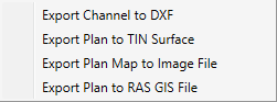
Then choose Export Plan to RAS GIS.
Next you will be prompted to specify a file name. Your export file will be created and saved promptly and will have an .sdf extension.
Below is an example of an actual RAS GIS export file.
# RAS GIS export file created on 03-09-2017
# by Channel Studio v 2.0.0.x
BEGIN HEADER:
UNITS: US CUSTOMARY
BEGIN SPATIAL EXTENT:
Xmin: 196.70
Ymin: 203.32
Xmax: 697.33
Ymax: 464.79
END SPATIAL EXTENT:
NUMBER OF PROFILES: 1
PROFILE NAMES:
5-year
NUMBER OF REACHES: 1
NUMBER OF CROSS-SECTIONS: 6
END HEADER:
BEGIN STREAM NETWORK:
ENDPOINT: 338.9444,389.9363, , 1
ENDPOINT: 756,267, , 2
REACH:
STREAM ID: Stream 1
REACH ID: Reach 1
FROM POINT: 2
TO POINT: 1
CENTERLINE:
338.94, 389.94, ,
440.00, 389.00, ,
534.00, 341.00, ,
610.00, 286.00, ,
756.00, 267.00, ,
END:
END STREAM NETWORK:
BEGIN CROSS-SECTIONS:
CROSS-SECTION:
STREAM ID: Stream 1
REACH ID: Reach 1
STATION: 450
CUT LINE:
747.36, 281.59
748.53, 251.62
REACH LENGTHS: 75, 75, 75
BANK POSITIONS: 0.3333333, 0.6666667
WATER ELEVATION: 106.16
PROFILE ID: 5-year
END:
CROSS-SECTION:
STREAM ID: Stream 1
REACH ID: Reach 1
STATION: 375
CUT LINE:
676.05, 285.54
671.54, 255.88
REACH LENGTHS: 75, 75, 75
BANK POSITIONS: 0.3333333, 0.6666667
WATER ELEVATION: 106.05
PROFILE ID: 5-year
END:
CROSS-SECTION:
STREAM ID: Stream 1
REACH ID: Reach 1
STATION: 300
CUT LINE:
607.24, 302.92
596.38, 274.95
REACH LENGTHS: 100, 100, 100
BANK POSITIONS: 0.3333333, 0.6666667
WATER ELEVATION: 105.88
PROFILE ID: 5-year
END:
CROSS-SECTION:
STREAM ID: Stream 1
REACH ID: Reach 1
STATION: 200
CUT LINE:
537.37, 360.67
514.93, 340.76
REACH LENGTHS: 100, 100, 100
BANK POSITIONS: 0.3333333, 0.6666667
WATER ELEVATION: 105.05
PROFILE ID: 5-year
END:
CROSS-SECTION:
STREAM ID: Stream 1
REACH ID: Reach 1
STATION: 100
CUT LINE:
438.25, 404.02
437.97, 374.02
REACH LENGTHS: 100, 100, 100
BANK POSITIONS: 0.3333333, 0.6666667
WATER ELEVATION: 104.03
PROFILE ID: 5-year
END:
CROSS-SECTION:
STREAM ID: Stream 1
REACH ID: Reach 1
STATION: 0
CUT LINE:
339.08, 404.94
338.81, 374.94
BANK POSITIONS: 0.3333333, 0.6666667
WATER ELEVATION: 104.00
PROFILE ID: 5-year
END:
END CROSS-SECTIONS:
BEGIN BOUNDS:
PROFILE LIMITS:
PROFILE ID: 5-year
POLYGON:
747.36, 281.59, 106.16
748.53, 251.62, 106.16
671.54, 255.88, 106.05
596.38, 274.95, 105.88
514.93, 340.76, 105.05
437.97, 374.02, 104.03
338.81, 374.94, 104.00
339.08, 404.94, 104.00
438.25, 404.02, 104.03
537.37, 360.67, 105.05
607.24, 302.92, 105.88
676.05, 285.54, 106.05
END:
END BOUNDS: